Feeds:
Posts
Comments

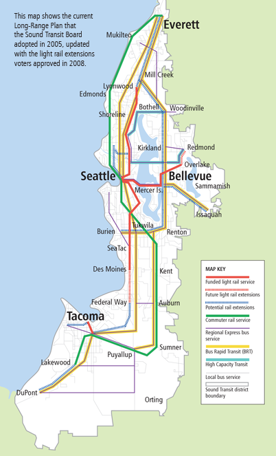
Sound Transit, the Seattle area’s regional transit provider, and the primary planner and builder of rail transit in the region, is updating its Long Range Plan.

I suggest modifying the Long Range Plan Map in three places:

Sound Transit 2005 Long Range Plan Map

Sound Transit 2005 Long Range Plan Map

1. Add a West Seattle potential light rail extension, from downtown Seattle to Burien.  Sound Transit has already scheduled a study of high capacity transit in this corridor.  This link will connect a Hub Urban Village (West Seattle Junction) with downtown Seattle and the Burien regional center, from where the Long Range Plan already shows a potential rail extension.  The transportation geography of West Seattle is particularly favorable for transit ridership.  All travel north or east of the “peninsula” must cross bridges in either the Spokane Street or 1st Av South corridors.  Transit already has a high mode share of downtown commuters due to favorable bus treatment on the West Seattle Bridge and SR 99.  However, the SR 99 tunnel will result in longer travel times and more congestion in the transit path.  Providing a completely grade-separated rail route between West Seattle and downtown will provide attractive, speedy and reliable transit service that will be well utilized.  This project should be considered for the ST3 funding package.

2. Add a potential light rail extension connecting the rail extension in Ballard to the high capacity transit route from Northgate to Bothell.  This connection rationalizes the potential rail extensions into a single line from downtown Seattle to Bothell via Ballard and Lake City.  This addition will connect the Hub Urban Villages of Ballard and Lake City to the Urban Center of Northgate.  This project should be considered for funding in the ST4 or future funding packages.

3. Change the line paralleling I-5 between Seattle and Tacoma from Bus Rapid Transit to High Capacity Transit.  High capacity transit is defined in the Long Range Plan as either BRT, light rail or commuter rail, mode to be determined.  This change in designation allows for future consideration of commuter rail in this corridor.  By the mid-21st century, the Puget Sound region should consider a new mainline rail corridor directly connecting Tacoma, Sea-Tac airport and downtown Seattle.  The corridor would be used for a second Sounder commuter rail line (all-day, two-way) and for regional high-speed rail (Cascades).  The line could utilize the I-5 right-of-way from Tacoma to south of Sea-Tac airport, the right-of-way for the proposed SR 509 extension from I-5 into Sea-Tac airport, and a bored tunnel under the airport and continuing underground near SR 99 to meet the BNSF mainline near Boeing Access Road.  This project should be part of a true long-range plan, to be implemented in cooperation with a high-speed rail authority.
I am reposting a link to my essay from the last King County Metro budget crisis, since two years have passed, the “temporary congestion reduction charge” is expiring, and Metro is once again planning 17% bus service cuts. 

This time around, however, I don’t support the mainstream rescue plan.  King County getting the option to vote for new transit taxes for $75 million per year, in exchange for several billion dollars in highway expansions, is not a fair exchange.  Metro should walk.  These highways go directly against the State Growth Management Act, Climate change mitigation goals and Vehicle Miles Travelled reduction goals.  Instead I support a King County “Plan B” of forming a Transportation Benefit District to levy a permanent vehicle license fee.

King County Transit, due to declining sales tax revenue, is faced with 17% system-wide cuts over the next 2 years, unless the County Council passes a temporary $20 car tab fee.  My rationale for why this budget-saver should be passed is posted over at the citytank: Dynamic Metropolitan Areas Depend on Transit, So Pass the Congestion Reduction Charge, Please.

Seattle is busy building the city.  Over the past year construction cranes have once again dotted the neighborhoods surrounding the urban core, building apartments and office buildings.  There are four city blocks under construction within two blocks of my South Lake Union office.  Local and national media have jumped on the trend.  Nationally, multi-family housing starts have ranged from one-sixth to one-third of the total over the past several decades.  How has the ratio of single-family to multi-family housing starts varied in the Seattle metropolitan area?

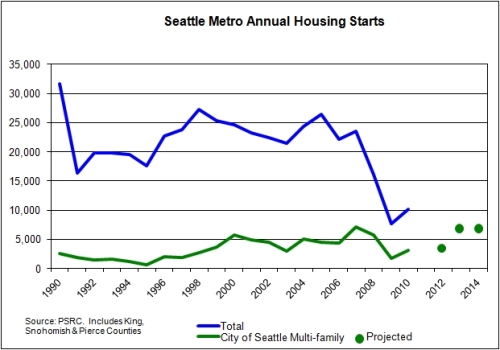
The Puget Sound Regional Council publishes such stats, so I was able to make some charts.  The first chart below shows total housing starts (in King, Snohomish and Pierce Counties) and City of Seattle multi-family starts, over the past 20 years.

During the 1990s, Seattle multi-family averaged at 9% of the total metro housing starts – a pretty small slice of the pie.  During the 2000s, the Seattle multi-family average increased to 23% of the total, and to 30% of the total since 2007.  When the recession of 2008 hit, housing construction tanked.  But single-family construction tanked worse than Seattle multi-family.  And now Seattle multi-family is roaring back to life, while suburban single-family plods along.  The chart includes projections of Seattle multi-family construction based on these articles: it appears that by 2013 multi-family construction in just the City of Seattle could nearly equal 2009 total metro area housing charts.  If suburban home construction continues at the same pace, nearly 50% of the total metro housing starts in 2013 would be apartments in the city.

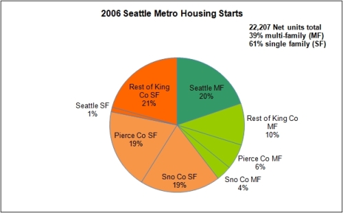
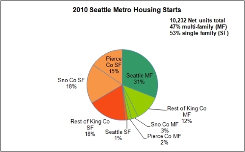
Below are pie charts breaking down the annual housing starts for the Seattle metro in 2006 and 2010.  Notice that the overall pie in 2010 is about half the size, while the Seattle multi-family slice has grown.

Data Source: Puget Sound Regional Council

Data Source: Puget Sound Regional Council

Best Buy, the U.S. electronics retailing chain, recently announced the locations of 48 stores to be closed.  The chain has been struggling for a while, and strategically plans to reduce their store sizes and shift towards a new line of storefront shops specializing in mobile devices.  This could be a symptom of the End of Retail.

However, based on a google map evaluation of each store slated for closure, I found that they are:

  • 50% are in exurban and small town locations
  • 39% are in suburban areas and small cities
  • 13% are in central cities.

Looks in line with the End of Exurbia meme instead.

Jane Jacobs, in the seminal Death & Life of Great American Cities, espouses the emergent traditional fabric of city streets and districts. Throughout the book it is implicit that residents, if asked, know what is best for their neighborhood, and these insights are in opposition to plans of idealistic planners, politicians and financiers. The well-intentioned official plans would actually destroy the functioning of the neighborhood, and the average person-on-the-street would recognize it and oppose it, if their voice is allowed to be heard.

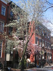
Greenwich Village, New York (Source: Wikimedia Commons, Urban)

Jacobs’ guidelines for successful city districts rest on a very high population density and diversity of uses, to provide the continuous “sidewalk ballet” of passersby, public figures and “eyes of the street” throughout the day and evening, even on quiet side streets. Shopkeepers keep an eye on neighborhood children; the mailman gets to know elderly residents who relax on front porches. Without this ballet the street cannot police itself and could become undesirable or dangerous. She decries the extensive “gray zones” that filled the outer portions of many cities, with a population density too low to support the “sidewalk ballet” yet too dense or industrial to be a green, pleasant suburb or a small town.

However, the vast majority of North Americans today live neither in the idealized small town community or the Jacobean city district. Instead, we live in an atomized suburban world of automotive arterials, television, internet, membership gyms, big box stores, programmed children’s activities, anonymity and long commutes. Small towns, suburbs, large cities, regardless: we essentially live the same lifestyle. Virtually every neighborhood, from the suburbs to the cities to small towns, functions as a “gray zone.” This is due as much to culture as to urban design.

Even in Greenwich Village, the prototypical city district, Jacobs noted that residents of the new elevator apartment building across the street didn’t interact with the neighborhood as much as the older residents. Those eyes on the street didn’t add as much. She implied that this was due to the building design. I believe was a marker of cultural change. Why would a resident of a fourth-floor apartment be more connected to the street if she walked up stairs to her flat instead of took an elevator? The new residents were simply less connected to the neighborhood than existing residents, who had been woven into a local fabric that took decades to develop. That local fabric didn’t die overnight; it would fade away slowly. But in newly constructed buildings, it would never develop at all. The rise of television was the symptom of an inward turn in North American culture, away from front porches and balconies towards the living room. Rising prosperity meant that you could rely on yourself to solve problems, instead of involving the neighbors. The automobile meant that you could shop and maintain friendships anywhere, not just your immediate neighborhood.

Outside of a handful of districts in cities like New York, Toronto, Boston, San Francisco, our neighborhoods have been converted to suburban functionality, where supermarkets are driven to and jobs are strictly separated from residences. Virtually every city in the United States, including New York, employs zoning codes developed for suburbia: setback requirements, open space minimums, height maximums. In Jacobs’ world the average neighborhood resident knew these requirements were antithetical to their neighborhoods, along with renovations to improve traffic flow such as freeway construction and street widening. Jacobs’ grassroots pro-city point of view was about preserving the existing neighborhood fabric. But sixty years of suburbanization has flipped the script: today’s residents implicitly know that free parking, wide arterials with free-flowing traffic, setbacks and separated uses allow their neighborhoods to function most conveniently.

Typical Seattle neighborhood scene (Source: Google Streetview)

Since the 1990s the limitations of the suburban model have been recognized by a growing “urbanist” movement: endemic traffic congestion, air pollution, loss of community, and global environmental problems like climate change and resource consumption. Urbanists look back appreciatively to Jane Jacobs and her insights in Death & Life of Great American Cities, looking for guidance. What does she say about urbanization, the process of converting greenfields, suburbs or gray zones into successful urban districts? Very little. Jacobs describes, historically, the ingredients of a successful urban district, in the face of a challenge to preserve that success against attrition.

Today’s urbanists face a challenge of cultural change. Many if not most political leaders and planners espouse urbanist principles: they want to create walkable live-work-play neighborhoods. Yet they are limited in action by opposed residents. We urbanists believe that converting to an urban structure will yield many benefits. But what if a majority of a neighborhood’s residents like it the way it is? Jane Jacobs faced a different political and cultural environment, and cannot tell us how to convert gray city neighborhoods and suburbs into thriving urban districts. We have to develop new tools.

On Sunday at this year’s Bumbershoot music festival, Macklemore was the hottest performer.  Fans wearing t-shirts filled the Seattle Center, and began lining up at 4:45 for an 8:00 pm show on the mainstage, the Key Arena. Why is Macklemore, an unsigned rapper, performing in a packed-out Key Arena, capacity 16,641?  It was a coming home party for the #206, a celebration that says we’ve arrived, northwest hip-hop has taken over the palace. While not as polished as the follow-up national act Wiz Khalifa, Macklemore brought local excellence,  musical diversity and most of all, fan devotion.  Yes, the packed-out Key Arena also cheered for Wiz Khalifa, but I saw no Khalifa shirts.  Macklemore didn’t come alone, but brought out Shawn Kemp in a poignant moment of Supersonics nostalgia, DJ/producer Ryan Lewis, a horn section, a string section and a crew of vocalists and dancers.  I’ve never seen a hip hop show with so many instruments on stage, with songs ranging from earnest heartfelt humility like The Town, celebrating the Seattle hip hop community, and the anti-drug the Other Side, to the all-out dance party celebration of Dance and Irish Celebration.  Macklemore represents an emergent local hip hop tradition, fully embraced by the region.  In an age of globalization and homogenization, Seattle (and every other place) needs to nourish our uniqueness and creativity, and build seasoned excellence.  It’s how you build a unique culture, a unique city.

Macklemore_Photo_by_Darin_Chin. Source: Wikimedia

On Friday I rode all the rail transit in the Seattle metro area.  It is possible to do this in one day (weekends only) due to the reverse-commute Sound Sounder runs.  Here’s the itinerary:

You can read my running commentary on the trips in my Twitter feed for August 5, 2011.  On the basis of my rides on Friday, I developed a rating matrix of the six rail transit modes, plus Swift BRT.  Three of the vehicles were waiting for me when I arrived at the station: the SLU Streetcar, Central Link and Tacoma Link.  If I hadn’t been so lucky, they would have lower ratings for frequency.   Swift, although it is bus rapid transit not rail, is included as well.  Bus transit, whatever other benefits it provides, simply cannot compete with rail in terms of ride quality.  My return trip from Everett to Seattle via bus was by far more exhausting than the commuter rail trip to Everett.

Service

Frequency

Experience of Speed

Ride Comfort

Ticketing Convenience

Transfer Convenience

Monorail

4

8

7

2

3

SLU Streetcar

6

3

7

6

4

Tacoma Link

8

5

7

10

8

Central Link

8

6

7

7

7

South Sounder

3

9

8

8

7

North Sounder

1

7

8

8

5

CT Swift

3

7

4

7

4

Below is a quantitative comparison of the six rail modes, plus Swift BRT. The surprise to me was the high ridership and frequency of the Monorail – it is actually the best performing rail service in the region. But then, it is by far the oldest (most mature) rail service in the region. Rail is still in its infancy in the Seattle region.

Service

Frequency
(Peak/Base/ Evening)

Average
Speed (mph)

Length
(miles)

Fares

Weekday
Ridership/ Mile

Year
Opened

Monorail

10/10/10

36

1.2

$2.00

3,400

1962

SLU Streetcar

10/15/15

7

1.3

$2.50

2,200

2007

Tacoma Link

12/12/24

12

1.6

Free

1,600

2003

Central Link

7.5/10/10

25

15.6

$2.00-$2.75

1,500

2009

South Sounder

25/–/–
(9 trips)

48

47

$2.75-$4.75

120

2000

North Sounder

30/–/–
(4 trips)

36

35

$2.75-$4.50

20

2004

CT Swift

10/10/20

22

17

$1.75

200

2009

King County Transit, due to declining sales tax revenue, is faced with 17% system-wide cuts over the next 2 years, unless the County Council passes a temporary $20 car tab fee.  My rationale for why this budget-saver should be passed is posted over at the citytank: Dynamic Metropolitan Areas Depend on Transit, So Pass the Congestion Reduction Charge, Please.

In late May I went on a European vacation, visiting four cities in two weeks: Prague, Vienna, Paris and Barcelona.  All four cities provide reams of insight into building the city, four interpretations based on different histories, cultures and climates.  It is impossible to exhaustively describe a city’s architecture, history, urban form, main sights and culture in a blog post.  So what follows are brief impressions of the cities, and comparisons one to another and to my hometown of Seattle.

First, a general note on history: European cities are widely perceived as ancient; artifacts of medieval urbanism and architecture.  True, to an extent, but the vast majority of neighborhoods I visited on this trip were built out in the nineteenth century as a result of Europe’s industrial revolution, which turned rural peasants into urban factory workers.  The cities’ building stock is not particularly older than Boston, New York or even San Francisco.  Paris was rebuilt during the Hausmann renovations of the late 1800’s.  Medieval Paris was almost entirely swept away, covered over with boulevards lined with buildings representing a high point of wealth, grandeur and gracious urban design.  The other cities visited have historic districts in their centers, dating back to the fourteenth century, yet most of what is considered “the city” was built in the 1800’s.  In some cases the winding, narrow medieval streets survive, yet the poorly-built, one-to-three story medieval building were all replaced with the nineteenth century with grand, solidly-built six-story edifices.  European cities were purposefully built, around 150 years ago, and built grandly.  It is within our means to build new cities along the same guidelines today.

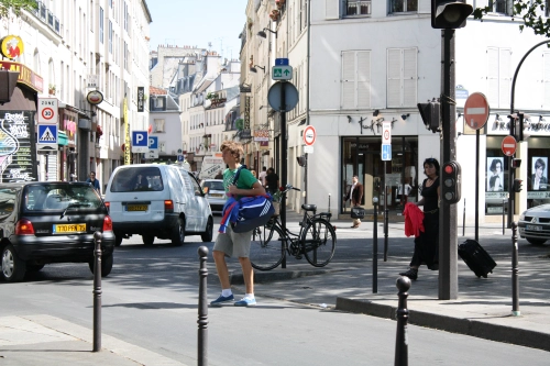
Paris versus Barcelona:  These two large Western European cities vie with each other to be the busiest and most stylish.  Both are very densely populated throughout the municipality (while having a wide range of suburban suburbs)and provide immense transit networks.  There is never a break in central paris:  no matter where you attempt to stop and take a photo, you will be in someone’s way.  The streets appear as canyons cut through a pre-existing mass of six-story buildings.

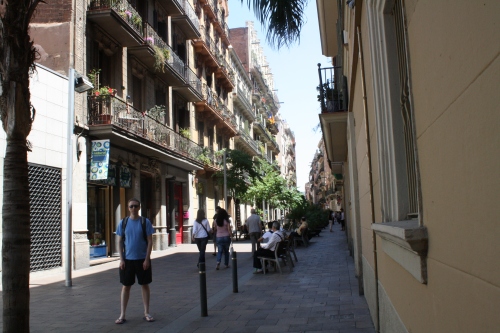
Now Barcelona, my favorite city of the trip, is in a whole different category.  The level of density and intensity went beyond the typical European city into an Asian realm.  People, people everywhere.  Shops, shops everywhere.  Bicycle and motorcycle are the only practical personal transportation devices.  Many streets were wide enough to accommodate a vehicle (such as an ambulance), but cars just aren’t practical in such as environment.  The question isn’t “is there a grocery store within walking distance?”; but “which of the half-dozen produce shops, bakeries, meat markets and supermarkets within two blocks should I go to?”  Streets are still crowded with pedestrians at midnight.  Our room faced onto a 10-foot “lightwell” fronted with windows into kitchens and bedrooms from other apartments.  The street-side windows faced towards the balconies across the street, a mere 20 feet away.  Basically, no privacy, no quiet.  But urban energy everywhere.  I loved it. 

Typical Barcelona street

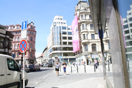
Prague versus Vienna:  These two central European capitals have similarly sized metro areas, in the same range as Portland and Vancouver.   Despite having top-notch transit systems, street-level activity paled in comparison to the larger Paris or Barcelona.  Yet, life was convenient, and many needs could be met within a few blocks.  Prague and Vienna are generally built on a grid of superblocks, with streets lined with continuous 6-story buildings holding large interior courtyards. 

An intersection in Prague New Town

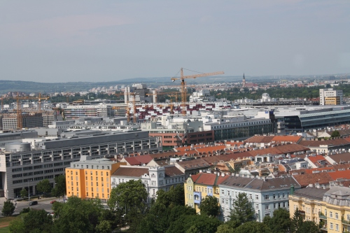
The streets have moderate width, similar to narrower Seattle streets, typically with at least one row of parked cars.  On busier streets, the ground floors house retail businesses.  On quieter streets retail is more rare.  The interior courtyards provide everyone access to ample greenery, as a view out the interior-facing windows or as a gardening or recreational area. Building coverage area is low as a result, as is the population density, which results in a lighter smattering of shops and quieter streets than Paris.  Vienna, in particular, appeared to be equally optimized for automobile as well as bicycle and public transit.  Car parks were common, as was separated bicycle  infrastructure.  The example of Vienna is the most applicable to Seattle: moderate density, eminently livability, lots of green space and transportation options.

Vienna is still under construction

I have an article up at the Pacific Northwest Clean Water Association, a trade newsletter for the wastewater utility business (my day job).  The article summarizes the big sustainability challenges we face, and some steps utilities can make to become more sustainable and resilient.  The article can be found here, beginning on Page 18.